GeoHECRAS Update: HEC-RAS Data, Data, Data

July 3, 2015 Release
This week we have released another major new update of GeoHECRAS. This update provides much more data functionality and control to the users by allowing them to view and edit the attributed data, merge different data types for a single application to get higher accuracy, and georeference HEC-RAS models to real world coordinates. One of the star features of this update is the new Conflate Point Data command, which is useful for the projects where the user needs to merge survey data and LiDAR data for creating cross sections.
We have received several feature requests from our clients these last few months, and the another star feature that we have implemented is the HEC-RAS Element Georeferencing command. Most of our customers complained that it is very difficult to georeference US Army Corps of Engineers HEC-RAS models to real world coordinates and river alignments. It took our software developers a long time to implement this, and our internal testers and beta user community have really stress tested this new feature to make it “world class”. You definitely need to check it out.
This new update will help our users automate complex and time-consuming data processes. Moreover, while our “Export and Import” data functionality has always been a major strength, it is now further enhanced with much greater data manipulation flexibility.
There’s more in the bucket. Here are the highlights:
What’s New
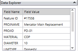
Data Explorer
The Data Explorer allows the user to view and edit the attribute data of loaded GIS layers, such as shapefiles, personal geodatabases, and file geodatabases.
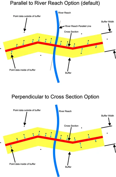
Conflate Point Data command
This command allows survey point data to be merged into HEC-RAS cross sections for defining the cross section geometry. This is especially helpful in projects where there is no cross section bathymetry data available for cutting of cross sections. This command works with XYZ point files, AutoCAD drawings, and GIS point shapefiles. Define a buffer distance for the cross sections and the software will automatically snap point data to the cross section. Snapping of survey data can be either perpendicular to the cross section or parallel to the river reach polyline. Restrict merging of survey data to channel only, left or right overbanks, both overbanks, or the entire cross section.
HEC-RAS Element Georeferencing
Georeference old HEC-RAS models to real world coordinates and river alignments. Snap river reaches to river alignment centerlines. Drag a river reach upstream or downstream along the river alignment centerline to correctly locate roadway crossings, inline structures, and cross sections along the river. Snap roadway crossings, inline structures, and cross sections to alignment lines. Move, rotate, and redraw roadway crossings, inline structures, and cross sections to place in their correct locations.
Base Map Exported to AutoCAD Model
When exporting a HEC-RAS model to AutoCAD, the base map imagery is clipped, georeferenced, and exported along with the AutoCAD drawing file.
Bridge Crossing Scour Calculator
Compute potential scour at a single bridge opening using the methods detailed in the FHWA’s “Evaluating Scour at Bridges” (HEC-18) document. The effects of contraction, pier, and abutment scour can be considered.
Elevation Controlled Gates
Control opening and closing of inline structure gates based upon:
- Water surface elevation upstream of the inline structure
- Difference in water surface elevation between two user-defined reference locations
- Water surface elevation at a user-specified cross section or storage area
- The rate that the gates open and close can be controlled.
Steady Flow Interior Change
The Steady Flow Data dialog box supports the HEC-RAS interior change option. This allows a specific change to the water surface elevation or energy gradeline elevation to be defined along a river reach. The interior change can be defined for a specific profile or multiple profiles.
Elevation Grid Color Relief
The software can compute a color ramp and generate a corresponding color relief from Elevation Grid Properties dialog box. The generated color relief is saved along with the elevation grid so that will be available with the project file the next time the project is loaded.
Automatic Reprojection and Unit Conversion
The software will automatically reproject data sources from other coordinate systems to the project coordinate system. For example, importing shapefile data that is defined in a lat-long coordinate system will automatically be reprojected into the project coordinate system. Similarly, importing elevation data that is in a different unit base (i.e., metric units) will automatically be converted to the project units (i.e., US units).
Flood Depth Grid
Generate water surface depth grid based upon the elevation difference between the computed water surface elevation and river bathymetry. This depth grid can be color contoured by depth as well as exported in common elevation grid formats.
FEMA NFHL Encroachment Station Assignment
Automatically assign FEMA National Flood Hazard Layer (NFHL) floodway stations from GIS mapping coverages to HEC-RAS cross sections for floodway computation encroachment method #1.
FEMA NFHL Data Download
Automatically download FEMA National Flood Hazard Layer (NFHL) map data for selected project area as ESRI shapefiles. This data can be converted to a AutoCAD drawing if needed for annotation of existing floodplain maps.
Favorite Coordinate Reference Systems
Mark specific coordinate reference systems (CRS) as favorites for quickly assigning typically used CRS projections to a new project.
2D and 3D Terrain Elevation and Flood Depth Tracking
Track the terrain elevation or flood depth at the cursor location while in 2D or 3D view. The terrain elevation or flood depth is displayed on the status line adjacent to the cursor location coordinates.
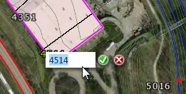
Rename HEC-RAS Elements directly on Map View
Double click on any HEC-RAS element ID label on the Map View and then rename the element. No need to display corresponding data dialog box.
See screen capture.
Report Generator
Access HEC-RAS’ Report Generator directly from within GeoHECRAS. Specify input and output report options, report formatting, and more.
Warnings & Notes Report
Access HEC-RAS’ Errors, Warnings, and Notes Report directly from within GeoHECRAS. See where in the defined model potential problems exist.
What’s Updated
Enhanced Roadway Crossings and Inline Structures
The roadway crossings (bridges) and inline structures (dams) shown on the Map View are plotted in true 3D, representing what would exist in the real world. Additional display enhancements are planned to further make these structures look photorealistic.
Export HEC-RAS to Shapefile Command
Improvements have been made to provide more control on the HEC-RAS element types and attribute data to be exported to GIS shapefiles.
Generate Terrain Command
Optimization of the terrain surface generation speeds up creation of the elevation grid, as well as memory optimization to reduce the amount of memory required for creating the elevation grid.
Assign Channel Banks Command
This command has been improved to provide additional options for assignment of channel bank station locations.
Assign Ineffective Flow Areas & Assign Conveyance Obstructions Commands
These commands have been improved to provide additional options for assignment of ineffective flow areas and conveyance obstructions.
Extract Cross Section Geometry Command
This command has been improved to retain key cross section information (e.g., levee stations, ineffective flow areas, conveyance obstructions, bank stationing, river centerline station, etc.).
Cross Section Hydraulic Parameters Command
The Hydraulic Parameters – Cross Section dialog box now includes a cross section plot to assist the modeler in defining the rating curve minimum elevation, increment height, and number of points.
Bridge Opening Hydraulic Parameters Command
The Hydraulic Parameters – Bridges & Culverts dialog box now includes a bridge opening plot to assist the modeler in defining the rating curve minimum elevation, increment height, and number of points.
Cross Section Geometry Creation
The software is able to work with floating point elevation grids to create detailed cross sections for low relief elevation areas.
Output Result Dialog Boxes
The software no longer closes any of the output dialog boxes (i.e., Cross Section Plot, Profile Plot, Detailed Output Table, Summary Output Table, etc.) unless the user changes scenarios (plans) or closes the project. This allows the modeler to view multiple output data while defining changes to the input data.
What’s Fixed
Map Data Layer Panel Drag and Dropping of Layers
Improved the drag and drop reordering of layers displayed within the Map Data Layer panel.
Assign Manning’s Data Command
Specific situations created issues in assigning Manning’s roughness data from GIS coverage data.
Structure Shifting on Map View
Roadway crossings, inline structures and lateral structures would sometimes shift the location on the Map View after editing the corresponding definition data. This is now prevented.
Improved Importing of Georeferenced HEC-RAS Models
The software provides additional options and control when importing georeferenced HEC-RAS models. This helps in correct alignment of river reaches, cross sections, and structures.
Numerous Bug Fixes and Crashes
Many small bugs and crashes have been fixed.
Find more information on our Knowledge Base or join the conversation about GeoHECRAS. Follow us on Facebook, Twitter, LinkedIn, and Google+ using #GeoHECRAS, #ReadyToEngineer.