Call us 800-488-4110 (Toll Free)


See how GeoHECHMS simplifies your drainage projects. Book a demo
GeoHECHMS greatly speeds up the creation, analysis, and review of stormwater models. It automates subbasin delineation, curve number (CN) computation using land use and soils maps, and lag time (time of concentration) computation. GeoHECHMS is a data wrapper to the industry-standard US Army Corps of Engineers HEC-HMS software using an AutoCAD compatible graphical user interface. Quickly compare different scenarios and alternatives, such as pre-development conditions with different post-development designs. Rapidly construct, design, analyze and compare detention and retention ponds. Both US and metric (SI) units are supported.
GeoHECHMS Automated Stormwater Modeling Software (video 2:12 minutes)
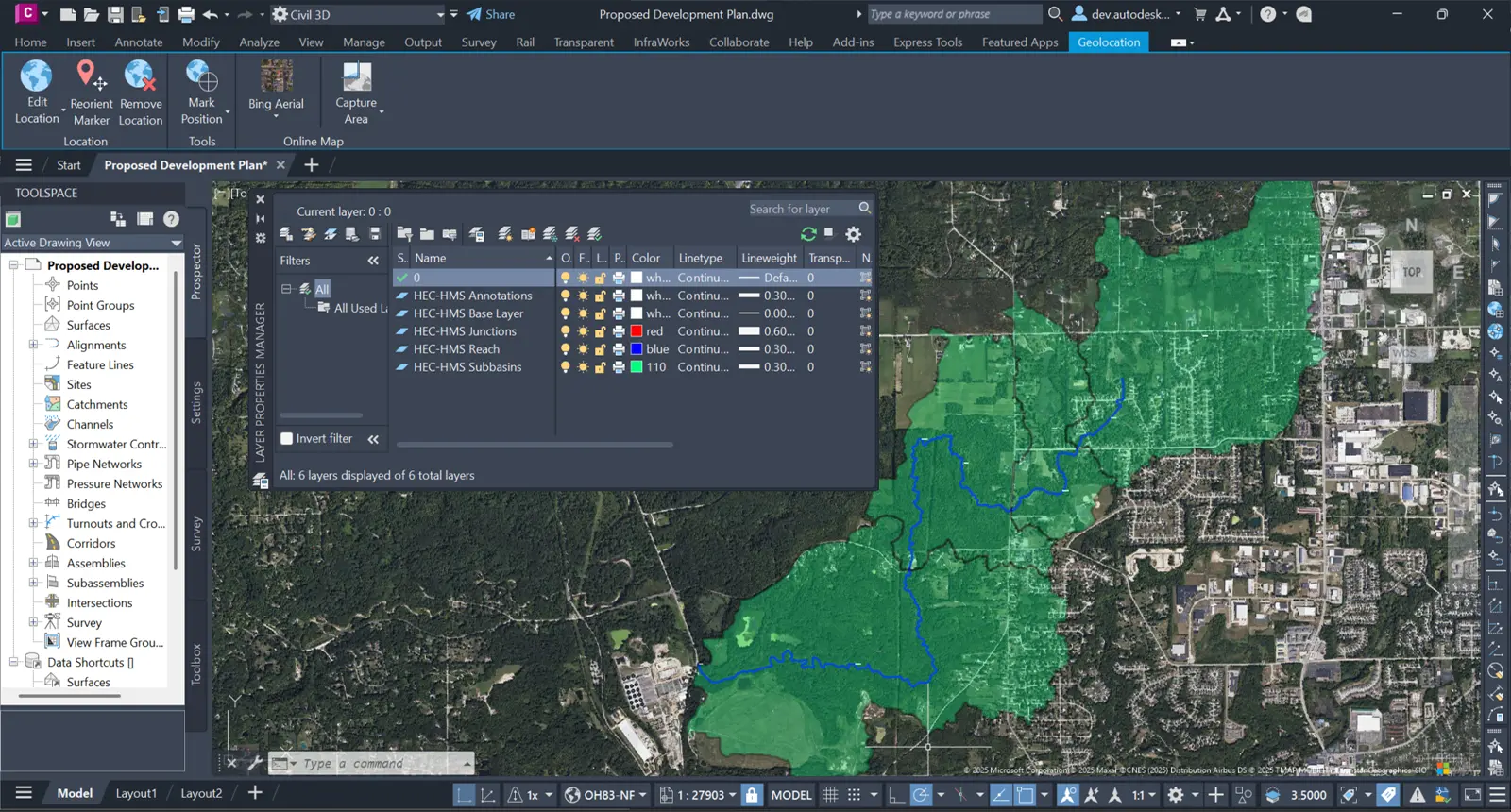
GeoHECHMS brings powerful 2D/3D graphical modeling to HEC-HMS hydrologic analysis within AutoCAD, Civil 3D, MicroStation, or ArcGIS. Transform complex watershed modeling into an intuitive visual workflow that streamlines data preparation, model development, and analysis for superior stormwater management results.
Work seamlessly with existing data—load Army Corps HEC-HMS and legacy HEC-1 models, then georeference them to real-world coordinates using integrated tools. Leverage past investments while modernizing workflows, ensuring continuity across projects and eliminating costly model recreation from scratch.
GeoHECHMS simplifies hydrologic modeling with an intuitive, easy-to-learn interface that automates time-consuming workflows. Build your HEC-HMS models faster through intelligent workflow automation that handles watershed delineation, data extraction, and model setup—letting you focus on engineering decisions, not tedious manual tasks.
Easily correct mistakes and explore design alternatives with full unlimited Undo and Redo capability. Make changes confidently knowing you can instantly reverse any edit, from simple subbasin edits to complex watershed delineations.
The workflow is similar to what we were used to before, but with CivilGEO it’s much more refined and more centric into one package…
GeoHECHMS allows me to bring in all the information I need, and greatly speeds things up…
Watch video testimonials to hear stories from other clients.
Accelerate stormwater projects with comprehensive automated workflows that handle watershed delineation, curve number computation, time of concentration and lag time analysis, imperviousness calculations, design storm assignment, detention pond sizing, and professional engineering report generation—transforming days of work into hours.
Work on multiple projects without switching applications. GeoHECHMS lets you load, edit, and run multiple HEC-HMS models simultaneously—compare alternatives side-by-side, manage different project phases, or keep client work organized. Boost productivity with true multi-model and multi-project capability that standard HEC-HMS lacks.
Work seamlessly within your preferred platform—AutoCAD, Civil 3D, MicroStation, or ArcGIS. GeoHECHMS integrates directly with CAD and GIS data, then exports completed models and results back to your design environment—eliminating data silos and maintaining unified project workflows.
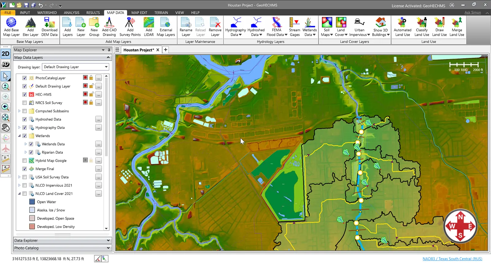
Automatically delineate subbasins and watersheds from any elevation data source—Civil 3D surfaces, MicroStation surfaces, contours, TINs, DTMs, DEMs, LiDAR, and more. GeoHECHMS intelligently analyzes terrain to generate accurate drainage boundaries in minutes, eliminating hours of manual digitizing.
Rapidly size and design detention and retention ponds to meet multiple design criteria. GeoHECHMS automates outlet structure development for various scenarios—balancing water quality requirements with storm event management—ensuring regulatory compliance while optimizing pond performance and minimizing construction costs.
Develop and compute HEC-HMS stormwater results directly within GeoHECHMS, no external data processing required. Read and write standard US Army Corps HEC-HMS data files, ready for regulatory agency submittal. Modernize legacy projects by importing HEC-1 models and automatically upgrading them to current HEC-HMS standards.
Compare different engineering models, such as existing and proposed development, different detention pond designs, and more. This allows stakeholders to evaluate alternatives, allowing you to consider more cost effective, innovative, and environmentally sensitive designs.
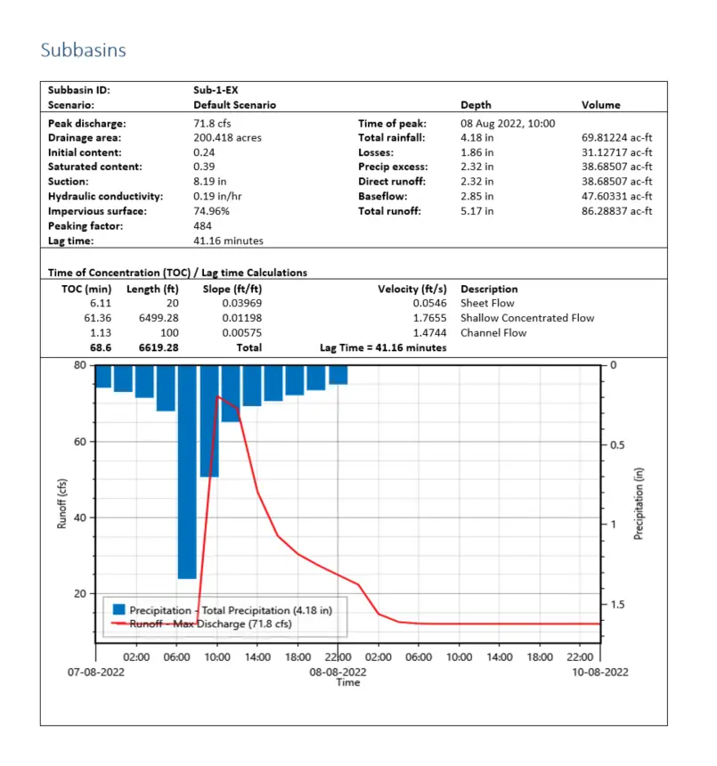
Generate polished, agency-ready reports automatically in Microsoft Word and Excel. GeoHECHMS creates comprehensive documentation including subbasin results, time of concentration, curve numbers, runoff plots, and results tables—all formatted to your specifications for professional project deliverables.
Tailor reports to meet any agency’s standard or client requirement. Customize layouts, add company branding, include specific data tables, and control what information appears. Save templates for consistent deliverables across all your projects.
Stop copying and pasting results from HEC-HMS into documents. GeoHECHMS automatically populates your reports with current model data, graphs, and images. When your model changes, regenerate updated reports in seconds—not hours.
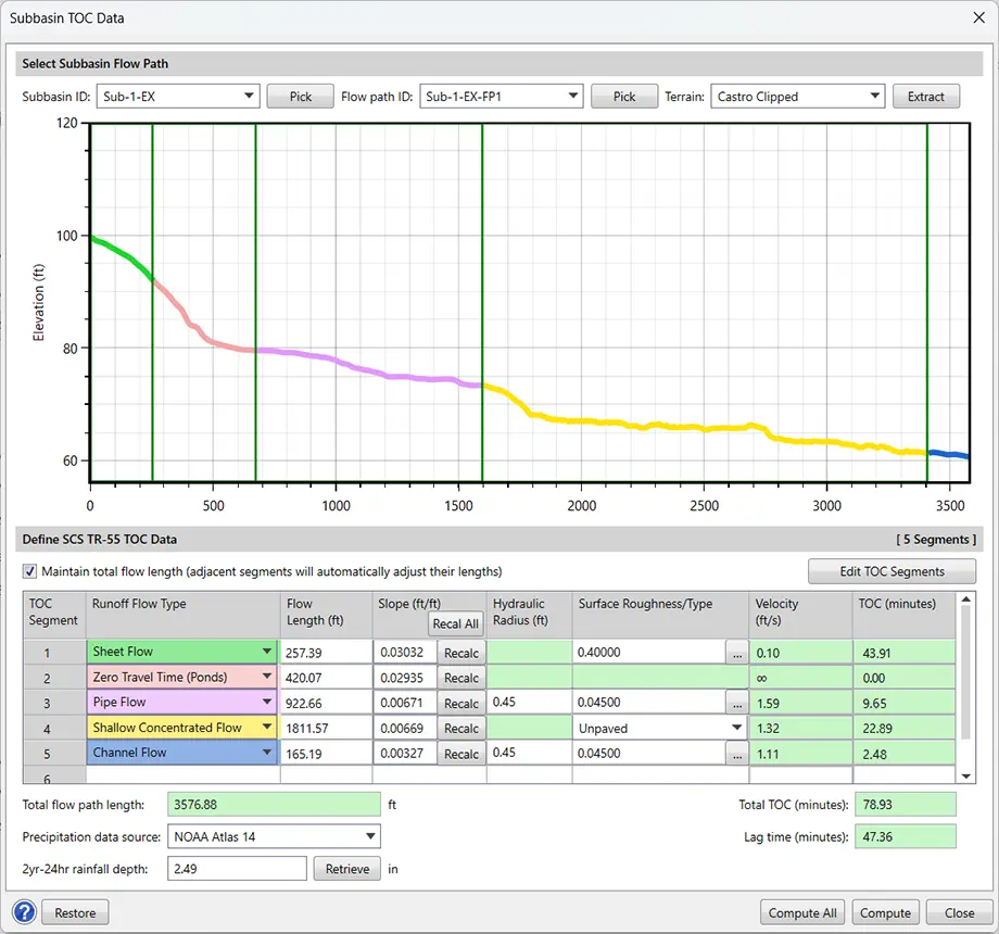
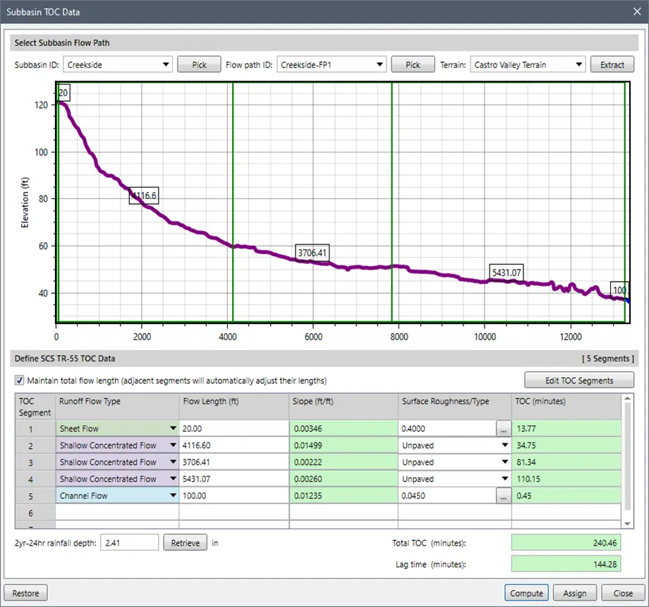
Automatically compute subbasin parameters including time of concentration (TOC), curve numbers (CN), and runoff coefficients. The software analyzes terrain data, land use, and flow paths to generate accurate hydrologic parameters in seconds—saving hours of manual calculations.
Build more accurate models with direct digital data integration. GeoHECHMS seamlessly incorporates field survey data, CAD drawings, and GIS datasets in multiple formats—ensuring your HEC-HMS models precisely reflect actual site conditions. Eliminate transcription errors and guesswork while saving hours of manual data entry.
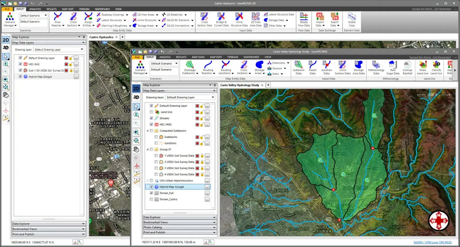
Seamlessly migrate HEC-HMS results to HEC-RAS for accelerated workflows. Complete flood studies, bridge and culvert designs, dam failure analyses, and stream restoration projects faster with integrated data transfer—eliminating redundant data entry and ensuring consistency across hydrologic and hydraulic models.
Overlay Google Maps, Bing Maps, or high-resolution aerial imagery directly onto HEC-HMS models. Quickly georeference existing models to background maps, AutoCAD/MicroStation drawings, or ArcGIS data—providing instant spatial context for better decision-making and presentation-ready visualizations.
Purpose-built stormwater tools streamline design workflows from concept to completion. Automatically update subbasin boundaries when terrain changes, rapidly design detention ponds and outlet control structures, and analyze dam failures—all within an integrated environment that eliminates software switching and ensures model consistency.
View your stormwater model in both 2D plan view and immersive 3D to gain complete project understanding. Switch seamlessly between 2D plan view for precise design work and 3D visualization for verifying elevations, identifying conflicts, and communicating designs to stakeholders.
Create stunning visualizations of design alternatives to communicate project impacts clearly to stakeholders and communities. Publish HEC-HMS models directly to Google Earth for immersive 3D visualization—transforming complex hydrologic data into compelling, easy-to-understand presentations that facilitate faster approvals.
Start modeling immediately with built-in high-resolution 1-meter elevation data covering the USA, Canada, Europe, and more. GeoHECHMS eliminates costly elevation data purchases and time-consuming imports—providing accurate, survey-grade terrain information ready to use the moment you launch your project.
Access comprehensive land use coverage for the USA, Canada, Europe, Australia, and beyond—built right in. Instantly compute composite curve numbers, time of concentration, lag times, and imperviousness without purchasing external datasets. Start modeling immediately with authoritative global data at your fingertips.
GeoHECHMS includes global impervious surface datasets spanning the USA, Canada, Europe, Australia, and more. Eliminate time-consuming manual work and expensive data purchases. Accurately determine imperviousness percentages, refine curve number calculations, and improve runoff estimates using high-quality built-in coverage for your project location.
Access comprehensive cloud-based mapping services and authoritative data directly within GeoHECHMS—including high-resolution LiDAR elevation data, FEMA flood maps, watershed delineation, soil classifications, land use datasets, and more. Eliminate time-consuming data collection and start modeling immediately with everything integrated.
Extract routing reach cross sections from diverse elevation data sources—Civil 3D surfaces, MicroStation surfaces, contours, TINs, DTMs, DEMs, LiDAR, and more. GeoHECHMS automatically converts extracted profiles to equivalent 8-point cross sections for streamlined HEC-HMS channel routing.
Manage large models effortlessly with intelligent automatic element naming. The software names subbasins, reaches, junctions, and other elements based on your specifications—sequentially, by routing distance, or incrementally—maintaining consistent organization across hundreds of elements without tedious manual input.
Automatically retrieve precipitation depths and storm distributions for 1 to 500-year events across the USA, Canada, and many European countries. GeoHECHMS queries authoritative databases by project location—eliminating manual atlas lookups and ensuring regional code compliance for accurate, defensible hydrologic design.
Rapidly compute SCS time of concentration and lag time with automated flow segment analysis—sheet flow, shallow concentrated flow, and channel flow. The software automatically determines overland flow paths, lengths, slopes, and travel times from digital terrain and land use data—no manual calculations required.
Compute composite SCS curve numbers, Green-Ampt parameters, and imperviousness using aerial mapping, GIS land use polygons, or simply painting regions on-screen. GeoHECHMS automatically calculates weighted averages across different land uses and assigns accurate values to each subbasin—effortlessly.
Perform simultaneous critical storm analysis in minutes across multiple storm frequencies, distributions, and durations. The software automatically evaluates all combinations to identify the critical design storm—eliminating manual iteration and saving hours of analysis time.
GeoHECHMS provides complete support for HEC-HMS and is FEMA-approved for National Flood Insurance Program (NFIP) stormwater and flood studies, ensuring regulatory compliance and acceptance by federal agencies, municipalities, and reviewing authorities nationwide.
Extend your engineering team with unlimited 24/7 toll-free support from experienced water resource engineers—not just software technicians. Get expert guidance on complex hydrology problems, modeling challenges, and design questions whenever you need it, at no additional cost.
Leverage AI-powered engineering assistance for real-time support with project review, simulation troubleshooting, and modeling questions. Get instant solutions to technical challenges and guidance based on engineering best practices—helping you work faster and more confidently.
Receive complimentary training tailored to your projects along with expert guidance from water resource engineers who support you from initial setup through project completion. Ensure your team is immediately productive and equipped with best practices for successful, efficient project execution.
Handle larger, more demanding projects efficiently with powerful 64-bit, multi-core, parallel processing capabilities. Process extensive stormwater networks, perform complex hydrologic calculations, and run critical storm analyses significantly faster.
| Capability | GeoHECHMS | HEC-HMS | PondPack | StormCAD | WMS | Hydrology Studio |
|---|---|---|---|---|---|---|
| Automated TOC & CN Calculations | ||||||
| Automated TOC & Lag Time Calculations | ||||||
| Automated CN & Green Ampt Calculations | ||||||
| Automated Watershed Delineation | ||||||
| Powerful Report Generation | Limited | Limited | ||||
| Automated Design Storm Assignment | ||||||
| Built-In Elevation Data Sources | Limited | |||||
| Integrated Terrain Modeling | Limited | |||||
| Automated GIS Mapping Functions | Limited | |||||
| Integrated 2D / 3D Viewing & Editing | ||||||
| CAD & GIS Integration | Limited | Limited | Limited | Limited | ||
| 24×7 Toll Free Technical Support | Limited | |||||
| Free Onboard Training | ||||||
| Free Engineering Project Assistance |
The workflow is similar to what we were used to before, but with CivilGEO it’s much more refined and more centric into one package…
GeoHECHMS allows me to bring in all the information I need, and greatly speeds things up…
Watch video testimonials to hear stories from other clients.
Water resource experts and leads at CEC, Matt Gramza and Steve Casey, sat down with CivilGEO’s engineering director, Chris Maeder…
The compatibility of GeoHECRAS with GIS and other applications like PCSWMM makes the pre- and post-processing aspects….
The use of GeoHECRAS for floodplain delineation has resulted in significant time and cost savings as well. Skupien notes that….
We use cookies to give you the best online experience. By agreeing you accept the use of cookies in accordance with our cookie policy.

When you visit any web site, it may store or retrieve information on your browser, mostly in the form of cookies. Control your personal Cookie Services here.