AQUAFOR BEECH LTD.
Performs Watershed Studies in Ontario, Canada
GEOHECRAS CUSTOMER SUCCESS STORY

The metropolitan area of Greater Sudbury, located within a striking geologic basin thought to have been created by meteoritic impact approximately 1.8 billion years ago, is home to over 300 lakes, ponds and waterways. Some 130 years ago, the earliest settlers to the region capitalized on the region’s nickel-copper ore deposits, launching an industry that would play a significant historic and economic role in the area for decades to come. Several years ago, the City of Greater Sudbury elected to take action to address a diverse set of environmental concerns. Extensive watershed and subwatershed studies were initiated for several of the city’s lakes and waterways.
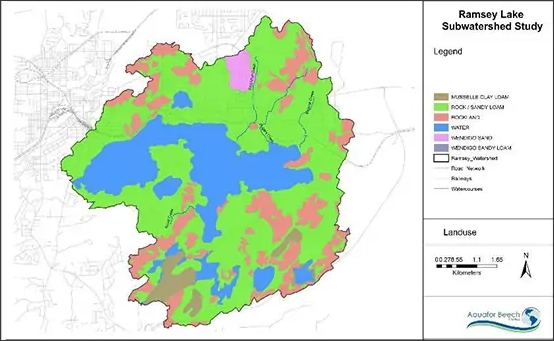
The primary objective of the subwatershed studies was to gather baseline data on the region’s natural resources, perform relevant analyses, and develop management strategies. Specifically, the community hoped to learn how to wisely guide future urban and residential growth, manage flooding and stormwater runoff, optimize ground and surface water quality, as well as enhance the region’s natural beauty and quality of life.
A Lake of Many Uses
Ramsey Lake is valued by the Greater Sudbury community for a variety of reasons: the lake is a primary source of drinking water for the city’s residents; it is a popular recreational destination, and increasingly, it serves as a focal point for the region’s identity and long-term viability. In other words, many believe that a healthy lake system will drive a vibrant and thriving community. But land area in the subwatershed of Lake Ramsey is poised for significant growth. Several large commercial and residential developments are planned for the lake’s shoreland zones. Conflicts between interests representing development, industry and natural resource protection are ongoing and common.
In addition to compromised water quality in the region’s creeks due to a history of mining and urbanization, flooding in specific areas continues to be a recurring problem.
Aquafor conducted a study to develop a Subwatershed Management Plan to protect, maintain and enhance the surface water, groundwater, and natural resources of Ramsey Lake and its tributaries through sound policy and management strategies.

About Aquafor Beech Ltd.
Multi-disciplinary environmental consulting firm Aquafor Beech Ltd. with offices in Mississauga, Kingston, London and Guelph, Ontario, was hired to perform a number of studies, including hydrologic and hydraulic analyses of the Lake Ramsey subwatershed.
Project contact and engineer at Aquafor Beech, Golmar Gol, notes that she used two principal software applications to model the major and minor flood profiles of Ramsey Lake’s subwatershed. PCSWMM was used to perform the hydrologic modelling work and GeoHECRAS was used to develop the hydraulic models and flood maps.

Modelling a Variable Landscape
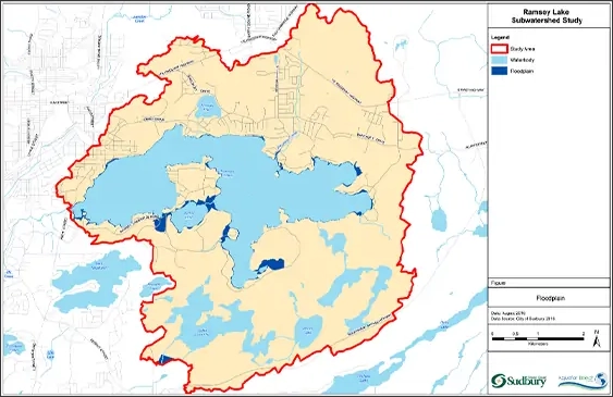
Due to the urbanized character of much of the land area, the model needed to incorporate multiple culverts, road crossings and other structural elements to generate accurate flood profiles for different storm events. These flood maps formed the basis for the quantification of flood hazards and identification of limitations in the existing storm water drainage systems. Modelling results also helped to formulate recommended flood and stormwater mitigation strategies.
The resulting report, Ramsey Lake Subwatershed Study and Master Plan (February 2020), presented several scenarios for the subwatershed with a variety of management alternatives. These consisted of a range of measures, from conveyance control options to end-of-pipe solutions and restoration strategies. Principal recommendations focused on retrofitting existing stormwater management facilities and implementing low impact development strategies to curb polluted runoff from existing and future development.
GeoHECRAS is User-Friendly and Compatible with Other Software
Golmar notes that GeoHECRAS is extremely user-friendly in terms of being able to import a broad variety of data from a variety of sources, manipulate cross-sections and structural elements, and run multiple hydraulic simulations efficiently. The compatibility of GeoHECRAS with GIS and other applications like PCSWMM makes the pre- and post-processing aspects of model construction with subsequent analysis of results cost-effective and timesaving. Use of the GeoHECRAS Scenario Manager made it possible to create effective visuals for purposes of presenting management alternatives to the public. Greater Sudbury is in the process of implementing some of the management strategies for the Lake Ramsey subwatershed, but the community’s work is far from over. Aquafor Beech continues to play an important role in the region’s environmental planning initiative and to use GeoHECRAS in the hydraulic analyses and assessments of the subwatersheds of Whitewater Lake and Whitson River.

Products
Company
Customers
Support
Training
Contact Us
 1-800-301-02-955
 608-729-5100
(US and Canada)
 [email protected]
 +1 608-729-5100
–
–
–Tel:
CivilGEO India
Graphix Tower, A-13 A
3rd Floor, Sector 62
Noida, Uttar Pradesh 201309
IndiaTel:
1-800-301-02-955 or
+91 022-3831-8601
Copyright
Copyright © CivilGEO, Inc. All rights reserved. The CivilGEO logo, “GeoSTORM”, “GeoHECHMS”, “GeoHECRAS”, and “Ready To Engineer” are registered trademarks of CivilGEO,Inc.
All other brands, company names, product names or trademarks belong to their respective holders.

 Advanced engineering software that is “Ready to Engineer”. Get started today!


