Tales in Geography: Early Cartographers Shape Modern Mapping

Throughout history, people have tinkered with some form of map making. The first depictions of place by early civilizations, such as those found in the Lascaux caves in France dating back some 20,000 years ago, were carved in rock with simple lines and symbols. Later drawings on clay tablets added additional features like rivers and small settlements. The first Egyptian maps, recorded between 1550-1070 BC on papyrus, showed the Nile and its floodplains, irrigation channels and simple estate boundaries. Roman maps charted ambitious military campaigns and vast networks of highways. Our modern uses of maps include geospatial computer programming applications, 3D renderings and more. In the field of civil engineering, maps, surveys and other sources of geographic reference are critical to a project, from start to finish.
The details of physical space and their importance to civil engineering projects form the cornerstone of our company, CivilGEO. So we thought it fitting to explore this topic in some detail. Who were the pioneers that came up with some of the key foundational concepts and helped us get to where we are today? This blog marks CivilGEO’s launch into a series that looks at pivotal moments in geographic history.
A Mathematician Named Ptolemy
Who, do you suppose, was the first to come up with the concept of mathematical coordinates? Who first described a scientific method for identifying physical locations on a map? Claudius Ptolemaeus (Ptolemy; AD 90-168) was a Greek/Egyptian astronomer, mathematician and scientist living and working during a very interesting time in Greek and Roman history.
Although not much is known of his early life, he spent much of his time in the celebrated library in Alexandria, home to some 700,000 books. In this intellectual space Ptolemy absorbed many ideas and put together his own theories about the earth, astronomy and other subjects including music and astrology.
Formative Ideas
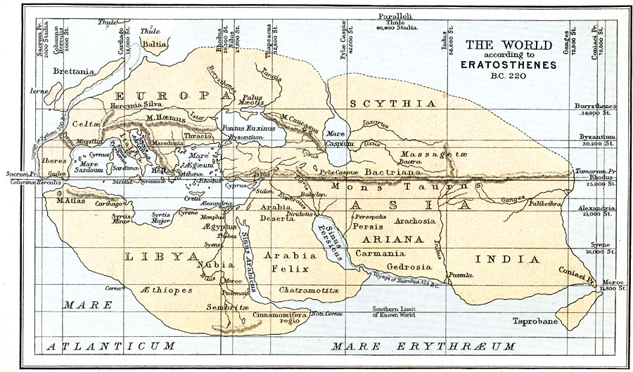
Although Ptolemy lived during Roman times, he was a product of his Greek upbringing and was strongly influenced by ideas circulated by his contemporaries. By this time, a heliocentric theory in which the sun is at the center of a system of revolving planets had already been proposed by the Greek philosopher, Philolaus. Euclid had completed much of his mathematical work and the geometric principles of lines, triangles, circles and other shapes became foundational to Ptolemy’s theories. Moreover, the chief librarian at the library in Alexandria where Ptolemy spent most of his time was Eratosthenes whose early world map formed a template for Ptolemy’s later work. Ptolemy built upon these ideas and others to piece together his own theories about the earth and the ways in which it could be represented.
Working Towards Representing the Earth on Paper
Well before Ptolemy and around 300 B.C., Dicaearchus, a student of Aristotle, ran a line of orientation across the world map, from west to east through Gibraltar and the Island of Rhodes, Greece. Eratosthenes and Hipparchus came up with the idea of imaginary lines drawn horizontally across the surface of earth. Eratosthenes and Ptolemy then worked with a system of parallels and meridians to develop a grid system. Their work included a method for projecting these grids as well. Ptolemy suggested that the lines of latitude be divided into degrees and minutes. The equator would be defined at 0 degrees and 90 degrees north at the North Pole. Lines of longitude were divided into 180 degrees east and west of a prime meridian, which Ptolemy set in the Canary Islands.

So Ptolemy shaped a grid over the surface of the earth that permitted places to be identified by their coordinates of latitude and longitude. These distinct locations could also be plotted relative to each other and to the entire earth. At last, with the use of projections, the spherical, three-dimensional world could be represented on a flat piece of paper.
The Beginnings of Maps as We Know Them Now
To use a grid to map physical space was both highly organized and highly mathematical and represented a systematic and objective way to visualize the world. John Rennie Short writes in his book, The World Through Maps:
“By simplifying the representation of the world to the abstractly geometric, a major revolution was wrought. The grid transformed the rough terrain of the world into a pure geometry, and allowed the world to be plotted and replotted, mapped and remapped, represented and reimagined.”
(Short, 2003, p. 21)
Ptolemy’s Monumental Guide to Geography
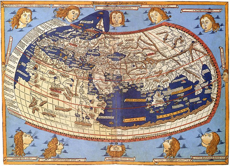
Ptolemy’s major work, The Guide to Geography, was an 8 volume masterpiece. The first volume discussed basic principles and dealt with map projection and globe construction. The next six volumes furnished a list of the names of some 8000 places and their approximate latitudes and longitudes. Many of these locations had been determined from older maps, with estimates of distances and orientation taken from the recorded travels of explorers and tradespeople.

The eighth volume of the Geography was the most significant contribution because it contained detailed instructions for preparing world maps at a variety of scales, both global and regional. It also discussed the mathematics behind geography and other fundamental principles of cartography. Ptolemy’s map of the world marked the pinnacle of Greek cartography. His work had significant impact in terms of helping scholars and others use mathematical analysis to construct maps.
Building on Ptolemy’s Work during the Age of Discovery and Beyond
Ptolemy’s work enjoyed a kind of revival during the 15th and 16th centuries where due to the efficiency of the printing press his Geography could be widely distributed. Geographic knowledge increased significantly during this time with the discoveries of Columbus, da Gama, Vespucci and Magellan. These explorers contributed to the geographic base of knowledge and this information further expanded on and transformed Ptolemy’s original world maps.
Ptolemy gave us this key mathematical foundation for modern map making. In so doing Ptolemy gave us the platform for our current system of identifying and mapping engineering project sites. We use a precise system of coordinates to ensure measurements to the smallest fraction. We use a grid system to know how one location is situated relative to another. We tend to take the grid and coordinate system for granted now in our engineering work, but someone had to be the first to propose it. The rest, as they say, is history.
Bibliography:
- Riffenburgh, Beau. (2014). Mapping the World, The Story of Cartography, London, England: Andre Deutsch Limited.
- Short, John, Rennie. (2003). The World Through Maps, A History of Cartography, Buffalo, New York 14205: Firefly Books Ltd.