GeoSTORM®
Greatly speed up the process of creating, analyzing, and reviewing stormwater models
- Overview
- Features
- Additional Features
- Comparison
- Client Videos
- Client Testimonials
- Case Studies
- Pricing
Civil 3D Integrated Stormwater Software
GeoSTORM is a Civil 3D integrated stormwater software that accelerates the process of creating, analyzing, and reviewing stormwater models, supporting numerous stormwater hydrology methods. The software is designed to manage stormwater models with varying complexity.
GeoSTORM Overview (video 01:30 minutes)
- Civil 3D Integration & Stormwater Element Catalog
- Automated Engineering Workflows
- Automated Engineering Report Creation
- Automated CN & TOC Calculations
- Automated Catchment Area Delineation
- Interactive Detention Pond Sizing and Designing
- Multiple Hydrology Methods Supported
- Free Training & Engineering Project Assistance
- 24×7 Technical Support
GeoSTORM Accelerates Your Engineering Process:
- Utilize AutoCAD Civil 3D in Your Stormwater Layout
- Extend Civil 3D’s Stormwater Parts Catalog
- Implement Automated Engineering Workflows
- Delineate Catchment Areas Automatically
- Determine Subbasin RC, CN, Green Ampt Values in Minutes
- Compute Time of Concentration Values Automatically
- Utilize State DOT and Major Foundry Storm Drain Catch Basins
- Calculate Storm Sewer Pipe Capacity, HGL, EGL
- Design Detention Ponds and Outlet Structures Interactively
- Generate Stormwater Engineering Reports in Minutes
Advanced Workflows
Automated Engineering Workflows
Accelerate stormwater design with intelligent workflow automation that builds complex models in hours instead of days. GeoSTORM handles repetitive tasks—pipe sizing, inlet placement, hydraulic grade line analysis—automatically maintaining engineering accuracy and consistency across projects while freeing you to focus on design decisions.
Civil 3D Integration
Link directly to Civil 3D pipe networks for seamless design-to-analysis workflows. GeoSTORM reads your Civil 3D data—pipes, structures, inverts, materials—eliminating redundant entry and ensuring stormwater models automatically reflect current designs. Update once in Civil 3D, analyze immediately in GeoSTORM.
CAD & GIS Integration
Work seamlessly within your preferred platform—AutoCAD, Civil 3D, MicroStation, or ArcGIS. GeoHECHMS integrates directly with CAD and GIS data, then exports completed models and results back to your design environment—eliminating data silos and maintaining unified project workflows.
Automated TOC & CN Calculations
Automatically compute subbasin time of concentration, curve numbers, and runoff coefficients in seconds. GeoSTORM intelligently analyzes terrain data, land use coverage, and overland flow paths to generate accurate hydrologic parameters—transforming hours of manual calculations into instant results for faster project delivery.
Client Videos
Stiffler McGraw & Associates, Inc.
We were able to test multiple flow paths for more accurate time of concentration calculation. Delineating the subbasins for us, I believe also is just a tremendous time save and really helps us to be more accurate with our results.
Andreas Consulting Services
All the firms that do stormwater use the NRCS or SCS method of runoff, and this is already in the software. So, it’s very easy to use. I don’t know any software in my 47 years of engineering that can do what GeoSTORM can do.
Jones & Associates Consulting Engineers
Previously, using other software, it took me about 48 hours to complete a project. Using GeoSTORM, I was able to complete it in about 10 hours. GeoSTORM is very efficient.
Features
Multiple Hydrology Methods
Choose the right approach for every project with comprehensive hydrological method support—Rational Method, Modified Rational, SCS TR-20/TR-55, EPA SWMM, CUHP, SBUH, and more. GeoSTORM adapts to your regional requirements and design standards, ensuring regulatory compliance and engineering accuracy.
Automated Catchment Delineation
Automatically delineate watersheds, subbasins, and catch basin inlets from diverse elevation data—Civil 3D surfaces, LiDAR, TINs, DEMs, survey data, and more. GeoSTORM intelligently analyzes terrain to generate precise drainage boundaries in minutes, eliminating manual digitizing and ensuring accurate runoff modeling.
Detention Pond Designing
Rapidly size and design detention ponds, retention basins, underground storage chambers, and outlet control structures meeting multiple design criteria. GeoSTORM optimizes configurations for water quality, peak flow control, and storage volume requirements—generating construction-ready designs with automated calculations that ensure regulatory compliance and cost-effective solutions.
What-If Scenario Manager Analysis
Compare multiple scenarios side-by-side, including existing versus proposed conditions and design alternatives. Evaluate different detention sizing options, pipe routing schemes, or LID strategies to quickly identify the most cost-effective and compliant solution for your project.
Automated Design Storm Assignment
Automatically retrieve precipitation depths and storm distributions for 1 to 500-year events across the USA, Canada, and many European countries. GeoSTORM queries authoritative databases by project location—eliminating manual atlas lookups and ensuring regional code compliance for accurate, defensible hydrologic design.
Roadway Catch Basin Inlet Design
Optimize inlet performance with automated catch basin analysis calculating capture efficiency, bypass flow, and gutter spread. Select from comprehensive catalogs of major US and Canadian foundry manufacturers and state DOT standards—ensuring code compliance while minimizing street flooding and maximizing drainage system efficiency.
Underground Detention Storage Design
Design and analyze underground detention systems for multiple design criteria with interactive 3D modeling. Select from comprehensive manufacturer libraries—ADS, Cultec, and more—then automatically generate construction drawings and engineering calculations. Deliver complete AutoCAD plans and professional reports in minutes, not hours.
Automated Sequential Naming
Automatically name pipes, structures, inlets, and other elements using customizable conventions—sequential numbering, routing distance, or location-based schemes. GeoSTORM maintains consistent organization across hundreds of elements, eliminating tedious manual labeling while ensuring clear communication across design teams and simplifying future model updates.
Digital Terrain Cross Section Cutting
Automatically extract routing reach cross sections from diverse terrain sources—Civil 3D surfaces, MicroStation surfaces, TINs, DTMs, LiDAR, and more. GeoSTORM generates accurate channel profiles instantly, eliminating manual digitizing while ensuring hydraulic models precisely reflect field conditions for reliable flood analysis.
MDI Multiple Model Editing
Work on multiple projects without switching applications. GeoSTORM lets you load, edit, and run multiple stormwater models simultaneously—compare alternatives side-by-side, manage different project phases, or keep client work organized. Boost productivity with true multi-model and multi-project capability that other software lacks.
Professional Report Generation
Generate polished, agency-ready reports automatically in Microsoft Word and Excel. GeoSTORM creates comprehensive documentation including subbasin results, pipe network tables, inlet schedules, stormwater profiles, and more—all professionally formatted to your specifications for immediate submittal and client presentation.
Fully Customizable Report Templates
Tailor reports to meet any agency’s standard or client requirement. Customize layouts, add company branding, include specific data tables, and control what information appears. Save templates for consistent deliverables across all your projects.
Eliminate Manual Report Assembly
Stop copying and pasting stormwater analysis results into documents. GeoSTORM automatically populates your reports with current model data, graphs, and images. When your model changes, regenerate updated reports in seconds—not hours.
Integrated Cloud-Based Mapping
Access comprehensive cloud-based mapping services and authoritative data directly within GeoSTORM—including high-resolution LiDAR elevation data, FEMA flood maps, watershed delineation, soil classifications, land use datasets, and more. Eliminate time-consuming data collection and start modeling immediately with everything integrated.
Included High-Resolution Elevation Data
Start modeling immediately with built-in high-resolution 1-meter elevation data covering the USA, Canada, Europe, and more. GeoSTORM eliminates costly elevation data purchases and time-consuming imports—providing accurate, survey-grade terrain information ready to use the moment you launch your project.
Included Land Use Coverage
Access comprehensive land use coverage for the USA, Canada, Europe, Australia, and beyond—built right in. Instantly compute composite curve numbers, time of concentration, lag times, and imperviousness without purchasing external datasets. Start modeling immediately with authoritative global data at your fingertips.
Included Imperviousness Coverage
GeoSTORM includes global impervious surface datasets spanning the USA, Canada, Europe, Australia, and more. Eliminate time-consuming manual work and expensive data purchases. Accurately determine imperviousness percentages, refine curve number calculations, and improve runoff estimates using high-quality built-in coverage for your project location.
Automated RC & CN Calculations
Calculate composite runoff coefficients, SCS curve numbers, Green-Ampt parameters, and imperviousness using AI-powered aerial imagery analysis, GIS land use data, or manual delineation. GeoSTORM’s flexible approach delivers accurate hydrologic parameters instantly—whether automating large watersheds or fine-tuning specific areas for engineering precision.
Additional Features
Critical Storm Analysis
Perform simultaneous critical storm analysis in minutes across multiple storm frequencies, distributions, and durations. The software automatically evaluates all combinations to identify the critical design storm—eliminating manual iteration and saving hours of analysis time.
Seamlessly Share Data with HEC-RAS
Seamlessly migrate GeoSTORM results to GeoHECRAS for accelerated workflows. Complete land development projects, roadway design, bridge and culvert replacements, and flood study projects faster with integrated data transfer—eliminating redundant data entry and ensuring consistency across stormwater and hydraulic models.
XPSWMM Model Support
Import previously developed XPSWMM models directly into GeoSTORM while preserving all model data and parameters. Protect your modeling investment and avoid costly rework—GeoSTORM maintains complete fidelity of pipe networks, catchment areas, runoff coefficients, and design parameters.
FEMA Approved Software
GeoSTORM is FEMA-approved for National Flood Insurance Program (NFIP) studies, ensuring regulatory compliance and acceptance by federal agencies, municipalities, and reviewing authorities nationwide. Submit stormwater and flood analyses with confidence, backed by software trusted for critical infrastructure projects and official floodplain mapping.
Work Directly on the Map
Overlay Google Maps and high-resolution aerial imagery directly onto your stormwater projects. Visualize stormwater infrastructure in real-world context, validate designs against actual site conditions, and produce compelling project deliverables.
Unlimited Undo and Redo
Easily correct mistakes and explore design alternatives with full unlimited Undo and Redo capability. Make changes confidently knowing you can instantly reverse any edit, from simple stormwater pipe replacements to complex stormwater network modifications.
2D & 3D Viewing and Editing
View your stormwater model in both 2D plan view and immersive 3D to gain complete project understanding. Switch seamlessly between 2D plan view for precise design work and 3D visualization for verifying elevations, identifying conflicts, and communicating designs to stakeholders.
Digital Twin Stormwater Model
Build Digital Twin workflows connecting design, engineering, and operations teams. Create a synchronized virtual model that evolves from design, construction, to maintenance—reducing errors and miscommunication across all teams.
Expert Technical Support
Extend your engineering team with unlimited 24/7 toll-free support from experienced water resource engineers—not just software technicians. Get expert guidance on complex stormwater problems, modeling challenges, and design questions whenever you need it, at no additional cost.
Free Training & Engineering Assistance
Receive complimentary training tailored to your projects along with expert guidance from water resource engineers who support you from initial setup through project completion. Ensure your team is immediately productive and equipped with best practices for successful, efficient project execution.
AI-Powered Engineering Assistance
Leverage AI-powered engineering assistance for real-time support with project review, simulation troubleshooting, and modeling questions. Get instant solutions to technical challenges and guidance based on engineering best practices—helping you work faster and more confidently.
Powerful 64-bit, Multi-Core Support
Handle larger, more demanding projects efficiently with powerful 64-bit, multi-core, parallel processing capabilities. Process extensive stormwater networks, perform complex stormwater calculations, and run critical storm analyses significantly faster.
What makes GeoSTORM different?
| Capability | GeoSTORM | HydroCAD | Bentley StormCAD |
Autodesk InfoWorks ICM |
Autodesk InfoDrainage | PCSWMM | ||
|---|---|---|---|---|---|---|---|---|
| AutoCAD, MicroStation & ESRI ArcGIS Compatible Interface | Limited | Limited | ||||||
| Civil 3D Drawings, Terrains, Pipe Networks Integration | ||||||||
| Automated Time of Concentration Calculations | ||||||||
| Automated RC, CN & Green Ampt Calculations | ||||||||
| Automated Watershed & Catch Basin Delineation | ||||||||
| Stormwater Parts Catalog | ||||||||
| Import Survey, LiDAR, and Other Data Support | Limited | Limited | Limited | |||||
| Automated Underground Storage Chamber Designer | Limited | Limited | Limited | |||||
| Worldwide High-Resolution Elevation Data | ||||||||
| Digital Terrain Modeling and Modification | ||||||||
| Automated Design Storm Assignment | ||||||||
| Automated Sequential Naming | ||||||||
| 24×7 Toll Free Technical Support | ||||||||
| Free Engineering Project Assistance |
Client Videos
Stiffler McGraw & Associates, Inc.
We were able to test multiple flow paths for more accurate time of concentration calculation. Delineating the subbasins for us, I believe also is just a tremendous time save and really helps us to be more accurate with our results.
Andreas Consulting Services
All the firms that do stormwater use the NRCS or SCS method of runoff, and this is already in the software. So, it’s very easy to use. I don’t know any software in my 47 years of engineering that can do what GeoSTORM can do.
Jones & Associates Consulting Engineers
Previously, using other software, it took me about 48 hours to complete a project. Using GeoSTORM, I was able to complete it in about 10 hours. GeoSTORM is very efficient.
Client Testimonials
Case Studies
Other Case Studies
Jones & Associates Consulting Engineers
Tyson Roper of Jones & Associates Consulting Engineers in South Ogden, Utah, is highly knowledgeable about water engineering and its many complex….
Aquafor Beech Ltd.
The compatibility of GeoHECRAS with GIS and other applications like PCSWMM makes the pre- and post-processing aspects….
Stormwater Management Consulting
The use of GeoHECRAS for floodplain delineation has resulted in significant time and cost savings as well. Skupien notes that….
Most Popular
For Individuals and Small Teams
For Medium Sized Teams
For most common urban stormwater modeling analysis and design conditions.
Includes all capabilities contained in the Starter Plan.
Most Popular
For Large Teams
For complex 1D and 2D urban and rural stormwater models, and much more.
Includes all capabilities contained in the Starter Plan and Standard Plan.
GeoSTORM Plans Comparison
GeoSTORM is available in different sizes and options to be able to tackle simple to complex urban stormwater systems.
General Features | Starter | Standard | Professional |
| Unlimited Undo & Redo Easily correct mistakes with unlimited Undo and Redo capability. | |||
| 2D & 3D Viewing and Editing Shift seamlessly between 2D and 3D viewing perspectives to identify modeling issues and make required changes. | |||
| Work Simultaneously on Multiple Projects Work with multiple projects simultaneously including copying and pasting data between projects. | |||
| Automated Report Generation Comprehensive, easy-to-read stormwater project reports generated in Microsoft Word and Excel, customized to meet reviewing agency and project requirements. | |||
| Automated Engineering Workflows Numerous workflow automation tools offer more efficient ways to create and maintain engineering models. | Limited | ||
| 24×7 Expert Technical Support Toll-free 24-hour 7-day a week unlimited technical support by experienced engineers. They are just a phone call, Zoom, or MS Teams meeting away, ready to answer your modeling questions and assist you with your engineering projects. | |||
| Built-In Modeling Assistant Intelligent AI-powered modeling assistance is provided to assist with modeling questions and project troubleshooting. | |||
| Integrated Cloud-Based Mapping Services Provided underlying soil and land use cover data can be used to compute and assign Manning’s overland roughness, curve numbers (CN), runoff coefficients (RC) and more. | |||
| Worldwide 3D Elevation Data Make use of integrated high-resolution 1-meter digital elevation terrain data for USA, Canada, Europe, and other regions. | |||
| AutoCAD & MicroStation Drawing Support Integrate AutoCAD and Bentley MicroStation drawing files directly into your project. | |||
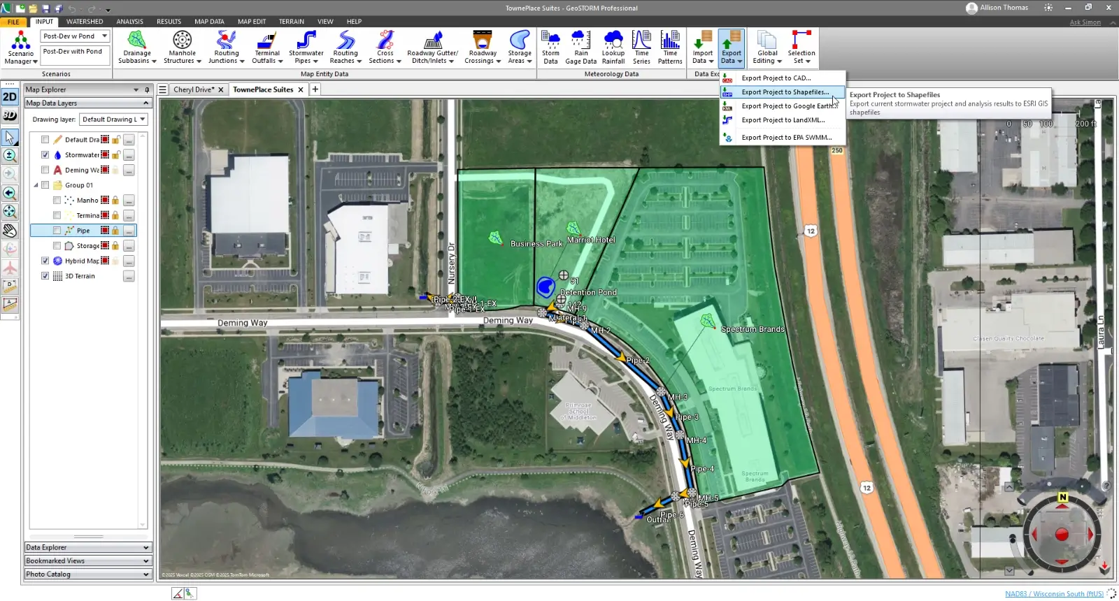
| Google Earth Support Export completed stormwater model input data and output results directly to Google Earth. | |||
| Link Elements Total number of pipes, routing reaches and roadway gutters supported. | Up to 20 | Up to 100 | Unlimited |
Modeling Capabilities | Starter | Standard | Professional |
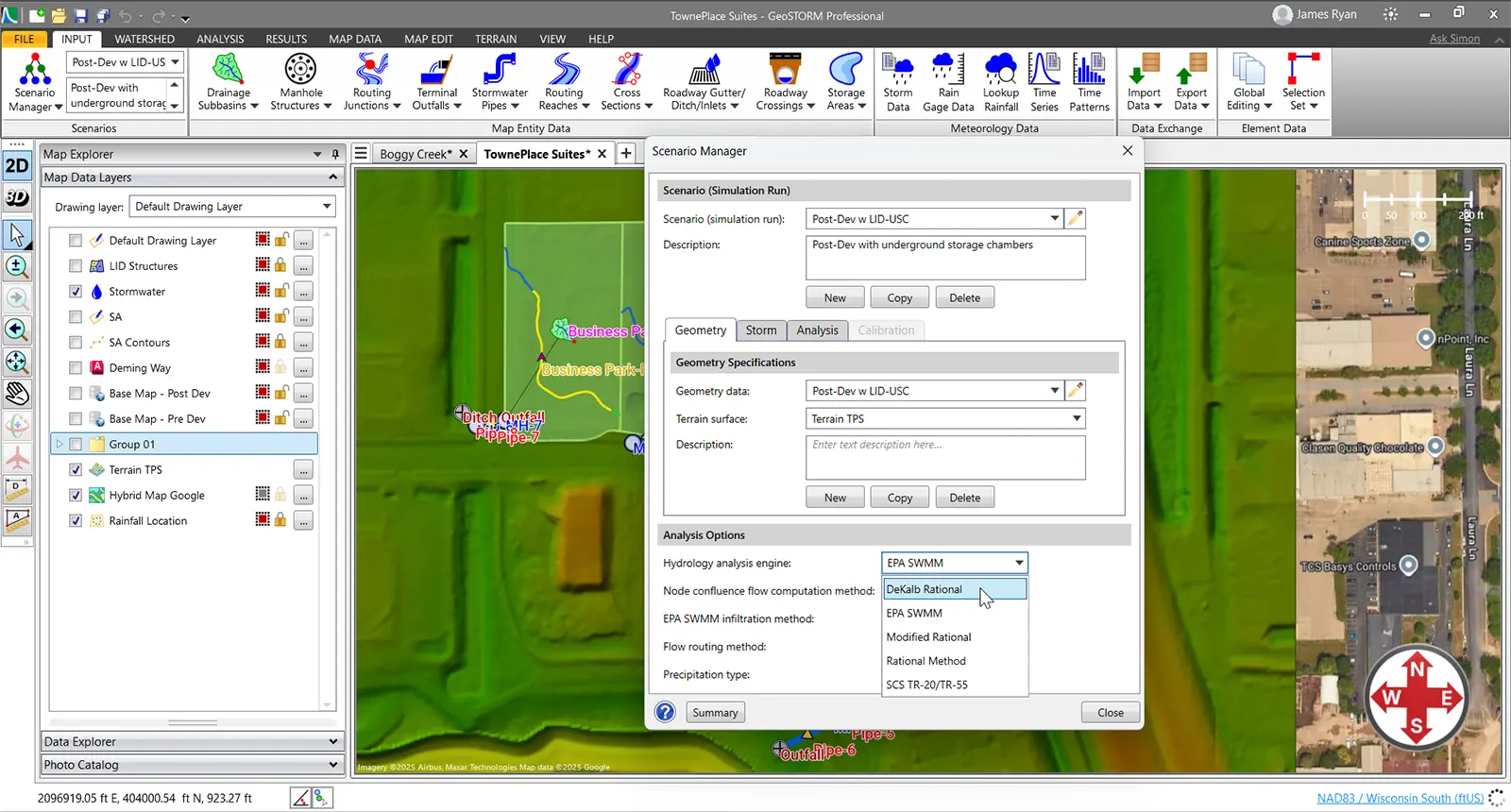
| What-If Scenario Manager Analysis Compare different engineering simulations, such as existing and proposed conditions, allowing quick evaluation of design alternatives. | |||
| Rational & Modified Rational Method Utilize Rational Method and Modified Rational Method for stormwater runoff computations. | |||
| SCS TR-20/TR-55 Utilize SCS TR-20 and TR-55 for stormwater runoff computations. | |||
| Catch Basin Modeling Included catch basin catalog which includes Neenah, East Jordan, OldCastle, Olympic and other foundries, as well as state DOTs, city and county catch basins allows quick sizing and designing of roadway stormwater inlets. | |||
| Denver CUHP Complete workflow automation support for the Denver region Colorado Urban Hydrograph Procedure (CUHP) stormwater runoff and routing computations. | |||
| Santa Barbara Unit Hydrograph Method Utilize Santa Barbara Unit Hydrograph (SBUH) for stormwater runoff computations. | |||
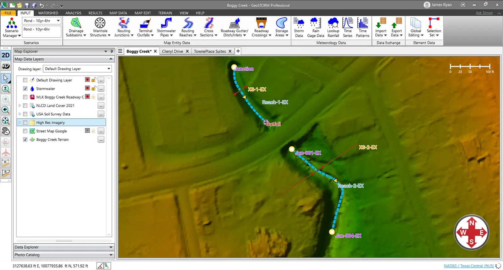
| Irregular Cross Section Geometry Extract routing reach cross section geometry from 3D digital elevation terrain data. | |||
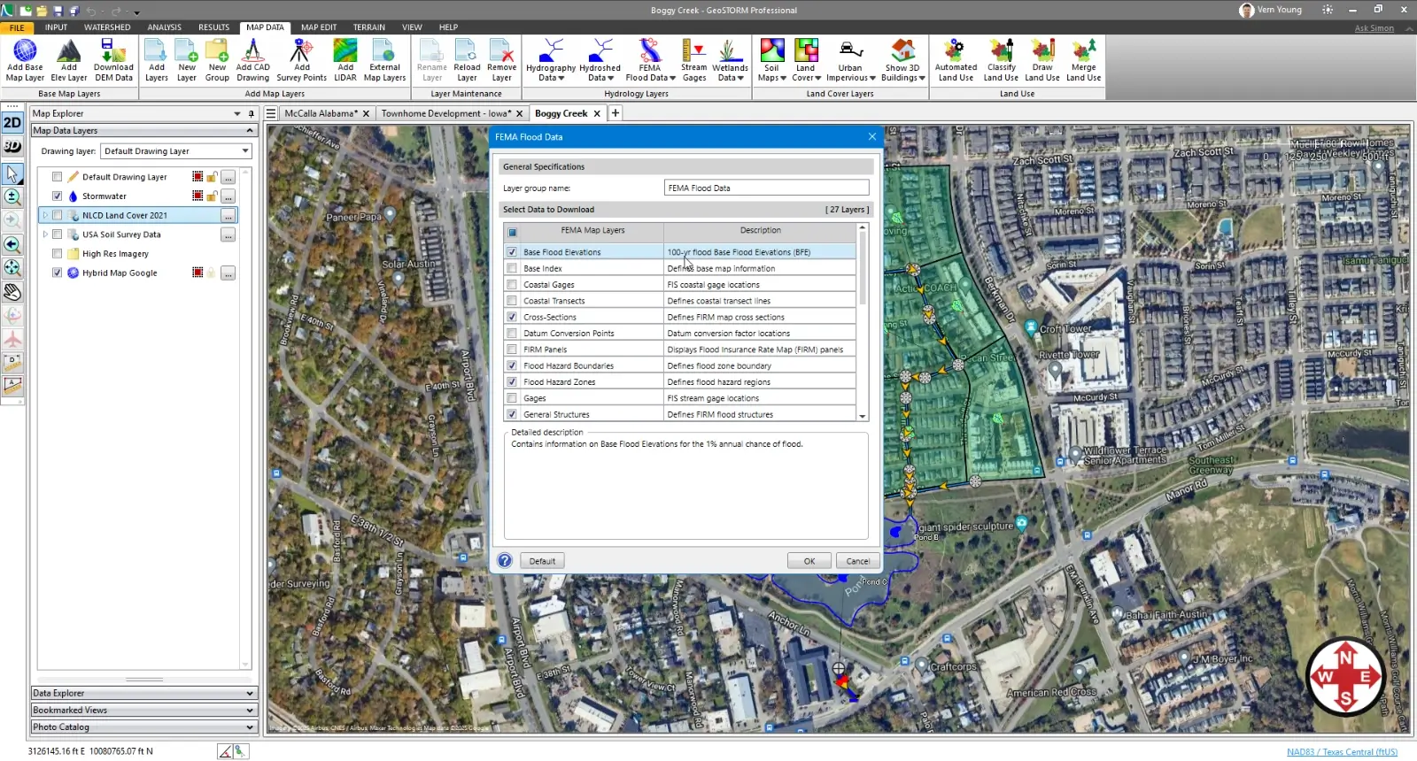
| FEMA Approved NFIP Stormwater Modeling FEMA approved for NFIP stormwater and flood projects. | |||
| EPA SWMM Hydrology Complete support for EPA SWMM is provided. | |||
| XPSWMM Model Support Import XPSWMM models to support and maintain existing and legacy stormwater projects. | |||
| Legacy Pipe Shapes (non-circular pipes) Support for non-circular pipes, such as arch, pipe arch, egg, basket handle and other pipe shapes. | |||
| Green Infrastructure Support Test out different combinations of green infrastructure elements, like rain gardens, bioswales, infiltration trenches, permeable pavement, and more to determine runoff capture effectiveness. | |||
| Pumping Support for pumping, including control rules for managing pumps. | |||
| Automated Critical Storm Computation Perform simultaneous critical storm analysis in just minutes, examining different storm frequencies and durations. |
Advanced Features | Starter | Standard | Professional |
| Automated Design Storm Assignment Automatically determine 1, 2, 5, 10, 25, 50, 100, and 500-year precipitation and storm distributions based upon project location. | |||
| Automated TOC Computations Automatically calculate subbasin TOC (Time of Concentration) using a variety of methods and computed terrain surface flow paths. | |||
| Automated RC, CN & Green Ampt Calculations Compare different engineering simulations, such as existing and proposed conditions, allowing quick evaluation of design alternatives. | |||
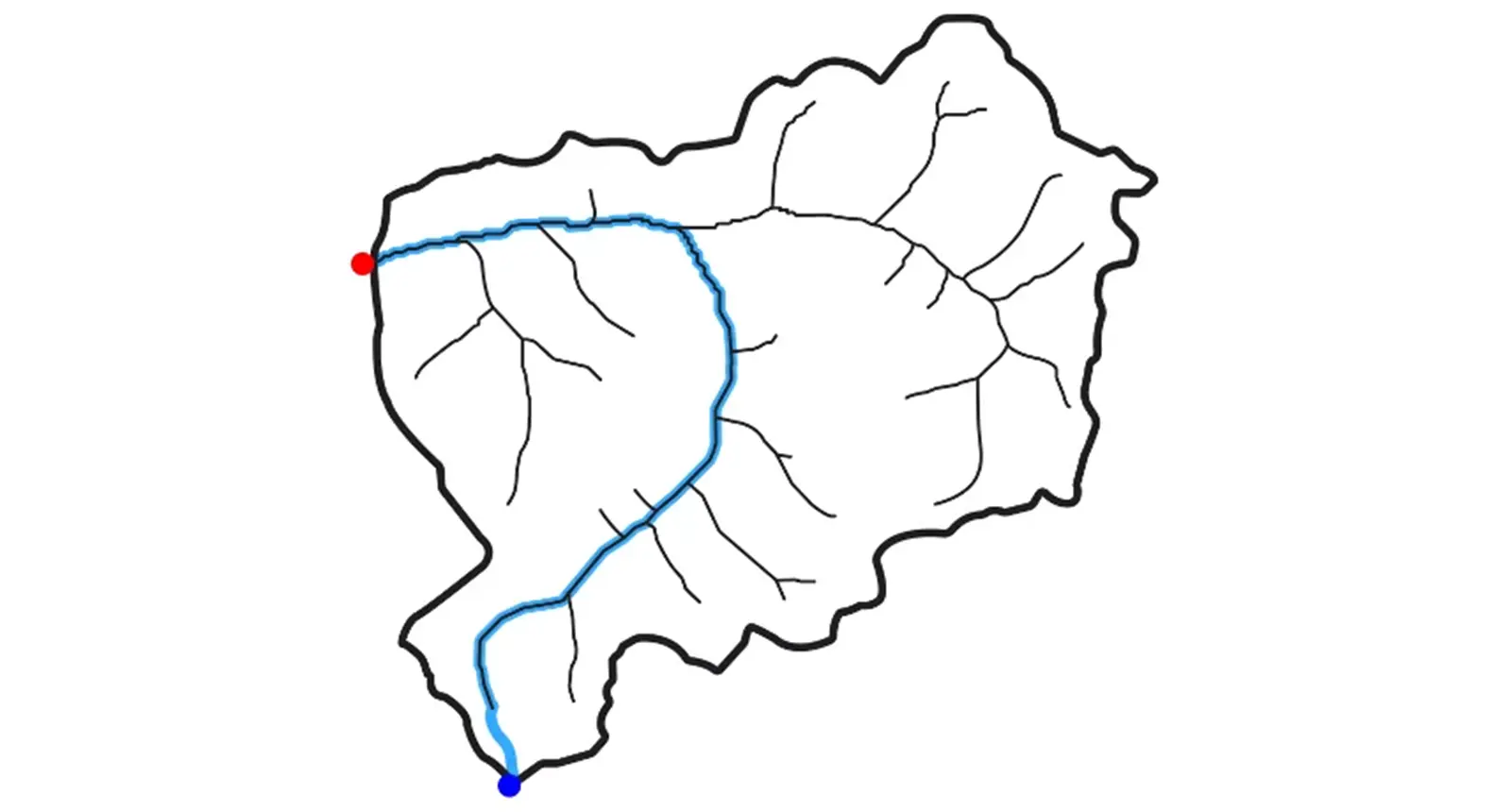
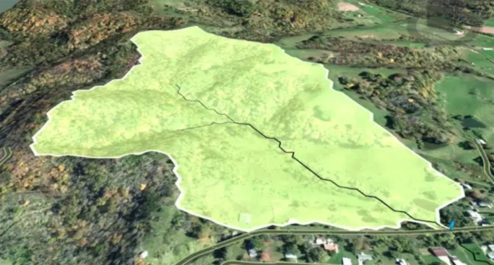
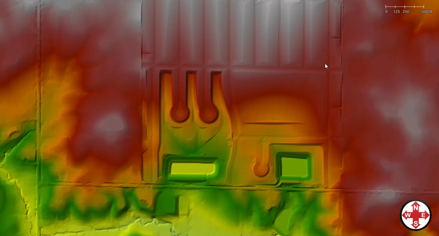
| Automated Subbasin & Catch Basin Delineation Quickly delineate watersheds, subbasins, and catch basin capture areas from 3D digital elevation terrain data, including AutoCAD Civil 3D surfaces, MicroStation surfaces, LIDAR, TINs, DEMs, survey data, and more. | |||
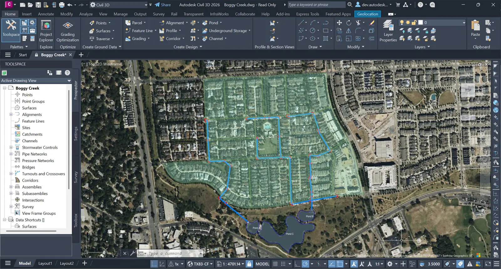
| AutoCAD Civil 3D Model Support Seamlessly import and export stormwater pipe network models from and to AutoCAD Civil 3D. | |||
| ArcGIS Support Seamlessly import and export stormwater models from and to ArcGIS. | |||
| Terrain Modeling Quickly create digital representations of existing and proposed ground topography using the included terrain modeling tools. | Limited | ||
| Underground Storage Chamber Design Tool Select elements from major storage chamber manufacturers, interactively size and design underground storage chambers and generate construction documentation and engineering reports. | |||
| Detention Pond Designer Quickly size and design detention ponds, retention ponds, underground storage chambers, and corresponding outlet structures for different design storms and engineering criteria. | |||
| FEMA Flood Mapping Data Provided high-resolution FEMA mapping data can be included directly in the project. |

